The State Marine Archeologist is responsible for the protection, preservation, and investigation of historic shipwrecks and inundated archeological sites in all state-owned waters of Texas.
Between the arrival of the earliest European explorers and the beginning of the 20th century, thousands of ships were wrecked along Texas shores. Ranging from sailing ships to steamboats, wooden hulls to steel, these vessels carried the vital goods of commerce between small communities, provided transportation for passengers, and performed the yeoman tasks of workboats everywhere.
Some wrecks, such as the La Belle, are significant because the vessels played prominent roles in our history, others because they represent types of vessels that have disappeared from our waters. The oldest shipwreck sites in North America, the wrecks of the 1554 Spanish Plate Fleet, were discovered by Vida Lee Connor in 1964 and were subject to THC investigations in the 1970s.
The State Marine Archeologist maintains an ever increasing inventory of these wrecks (more than 1,900 currently), reviews development projects in state waters for possible impacts to historic shipwrecks, and conducts archeological investigations to discover new sites, investigate known wrecks, and monitor protected archeological sites on public land, such as the state’s beaches.
A small group of avocational archeologists exists within the Texas Archeological Stewardship Network to assist the State Marine Archeologist with the investigation of historic shipwrecks. Known as marine stewards, these dedicated volunteers are vital to the operation of the Marine Archeology Program within the Texas Historical Commission (THC).
Staff members also conduct cultural resource management reviews for projects that might impact shipwrecks on state-owned submerged lands. For more updates and news focusing on Marine Archeology please visit our Blog to stay up to date.
With the vital assistance from several volunteer organizations, the THC conducts various projects around the state. Recent ongoing projects are described here.
Threshold of Texas
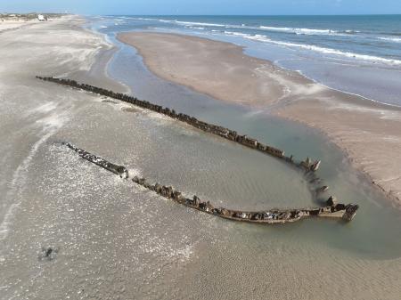
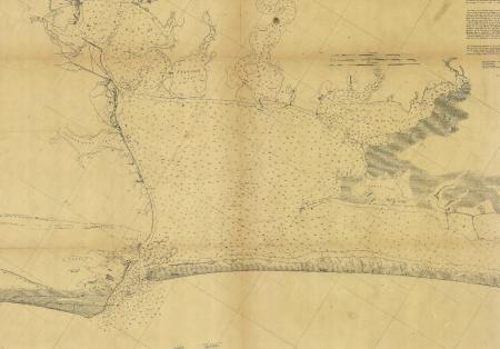
The Threshold of Texas project involves the investigation of numerous historic shipwrecks reported in and around Matagorda Bay, as well as the historic port of Indianola. The Spanish presence in the region increased in the 18th century after the failure of Robert Cavelier Sieur de La Salle’s settlement of Fort St. Louis. Two of his expedition vessels were lost in the region—L’Aimable in 1684 and La Belle in 1685. Later during the mid-19th century, the bay became a nexus for increased immigration from the United States and Europe, especially Germany.
The records of the State Marine Archeologist indicate that nearly 150 vessels were lost in Matagorda Bay and its historical entrance at Pass Cavallo, with more than 200 total reported shipwrecks in Calhoun and Matagorda counties. Studies completed at the entrance to Matagorda Bay by the THC in 1982 and in 2000 by the nonprofit National Underwater and Marine Agency, located the remains of 12 confirmed shipwrecks, including one that may date to the period of the Texas Republic and one that dates to the early 1800s. Marine remote-sensing investigations and THC dive investigations in 1995 and 2005-2007 located the historic wharves at the important 19th-century port of Indianola and remains of a shipwreck believed to be the steamship Perseverance. Perseverance was a Charles Morgan steamer that caught fire at Indianola and sank in 1856 after taking on a cargo of cotton and hides. Recent investigations of Indianola and Indian Point (Old Town) were commenced in 2016 by the Nautical Archaeology Program at Texas A&M University in partnership with the THC.
In addition, the THC is still seeking the location of L'Aimable, the missing supply ship from the colonizing voyage of La Salle. The THC will concentrate on investigating the wrecks in this area to better understand the seafaring history of this region and, through that history, the broader impact on the economic and social development of Matagorda and Calhoun counties. New THC underwater and terrestrial archeological investigations focused on the bay’s early 19th-century maritime landscape are planned for the upcoming years.
Emergency Fleet Vessel Investigations
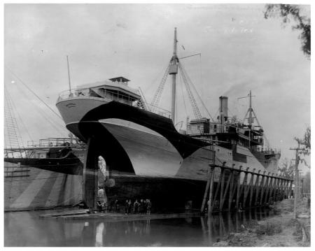
Near the end of World War I, the United States undertook a wooden ship construction program to bolster the badly depleted merchant fleets carrying vital war cargoes. The steamships produced during this period by the U.S. Shipping Board’s Emergency Fleet Corporation (EFC) were some of the largest wooden ships ever built. Numerous shipyards around the country took part in this program, including yards in Orange, Beaumont, Houston, and Rockport. Hundreds of vessels were constructed but few ever saw service, as the war ended before they were launched. Many of the unfinished hulls were abandoned in the Neches and Sabine rivers. The THC began investigating the hulks of several of these vessels in the Sabine River in 1999 to determine their state of preservation and historic significance. In 2006, agency staff dived on a wreck near Aransas Pass believed to be a former EFC-converted barge and in 2019 surveyed a portion of the Neches River to identify more abandoned, now submerged hulks. In total, more than 40 former EFC wooden, steel-hulled, and concrete shipwrecks have been discovered in the Neches and Sabine Rivers, near Aransas Pass, and at Galveston, Texas.
City of Waco
Galveston, as one of Texas’ oldest ports, has experienced its share of tragedies. These included not only the devastation wrought by hurricanes, such as those in 1900 and 1915, but also shipping losses caused by storms, mechanical malfunction, and fire. One of the port's well-known maritime disasters occurred in 1875 with the sinking of the Mallory Line steamship City of Waco. The 242-foot steamer was anchored off of Galveston riding out a storm when it inexplicably caught fire and sank. Though other vessels were nearby, the storm conditions prevented any aid to the vessel and all fifty-six on board were lost. This is the largest loss of life for any historic vessel lost in Texas state waters. The wreck was dynamited in 1900 to remove it as a hazard.
The wreckage of City of Waco was previously known, but in modern times had been misidentified as the 35-year-old dredge Galveston that sank in 1943. Marine remote-sensing survey of the wreck in 2003 helped re-identify the remains as City of Waco and diving at the site by the THC and the marine stewards in 2004 and 2005 confirmed this new identification. A new survey was conducted at the site in 2012 through a partnership between the THC and the National Oceanic and Atmospheric Administration’s (NOAA) Office of National Marine Sanctuaries and Office of Coast Survey. NOAA survey data demonstrates that the wreck appears to be unchanged since 2003 but has become more exposed by storm activity during the last decade.
The Monterrey Shipwreck Project
In 2013 the Marine Archeology Program participated in a limited artifact recovery project focusing on deep-water site 15577 and an examination of two nearby sonar targets approximately 180 mi. offshore Galveston at a depth of 4,300 ft.—collectively known as the Monterrey Shipwrecks. The shipwrecks were originally detected as unidentified acoustic remote-sensing targets in 2011 during a Shell Oil survey and a later deep-sea expedition by NOAA’s Office of Ocean Exploration and Research (OER) in 2012 confirmed site 15577 as an armed shipwreck.
The THC, with a team of federal and state underwater archeologists, collaborated in the planning and execution of the 2013 fieldwork that included NOAA OER and the NOAA Office of National Marine Sanctuaries, the Meadows Center for Water and the Environment at Texas State University, the Bureau of Safety and Environmental Enforcement, and the Bureau of Ocean Energy Management. This work was conducted under federal antiquities permit in partnership with Ocean Exploration Trust and their research vessel Nautilus. The recovered artifacts were conserved by the Conservation Research Laboratory at Texas A&M University. Site 15577 (Monterrey Shipwreck A) carried cannon and flintlock muskets, one shipwreck’s cargo was no longer present (or it was traveling in ballast), and the third carried hides. All three vessels are believed to have been lost in a single catastrophic event early in the 19th century. Additional remote video examination of the sites was conducted by the team in 2014 as part of the 2014 NOAA OER Okeanos Explorer Expedition. The artifact recovery project conducted at Monterrey Shipwreck A is the deepest project of its type to occur in the Gulf of Mexico.
Contact Us
If you have questions about the Marine Archeology Program, please contact the program administrator using the information listed here.
-
Phone:
+1 512-463-9505 -
Email:
marine.archeology@thc.texas.gov -
Address:
P.O. Box 12276
Austin, TX 78711
United States